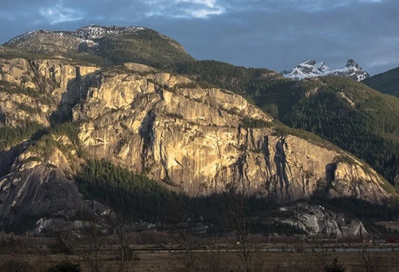
Stawamus Chief
An air of majesty
Officially known as the Stawamus Chief, this renowned granite monolith has been Siyam Smanit to the Squamish Nation for thousands of years. Siyam refers to a respected elder, role model or teacher and not always to a chief. Smanit means mountain in the Squamish language. This small yet conspicuous mountain is a place of spiritual significance; it is respected and full of meaning. Tsitsayxemmaat (Rebecca Duncan) told Mountain Life magazine, “It’s such a natural magnet. His strength and charisma, the magnitude of his power and being a protector.” These feelings run strong among Squamish Nation people. The Chief does have an air of majesty. Visitors need to avoid any disrespectful actions.
This is one of the largest granite monoliths in the world. A monolith is a geographical feature consisting of a single massive stone or rock. The Chief was created over 60 million years ago during violent volcanic eruptions, which thrust a huge blob of molten magma to the surface. This cooled to hard granite and the ice ages with their ebb and flow of glaciers wore off the softer outer layers.
Exfoliation in this harsh manner left behind the smooth surfaces we see today. Granite does not crumble nor erode; large flakes tend to shear away and drop off as happens about once every decade. The latest large flake fell off on April 19, 2015. The resulting accumulation at the base is called talus and not scree, which refers to smaller material.
The Chief is often described as the second largest granite monolith in the world after Gibraltar, though this is not accurate because Gibraltar is a much larger limestone monolith. El Capitan in Yosemite, Towers of Paine in Chile and Mount Augustus in Wales are all larger granite monoliths, so number four it is, certainly until soon proven otherwise!
The trail up starts with hundreds of stairs alongside Olson Creek named after Sam Oleson, a 1897 logger. When the stairs end, you get to scramble over rock ledges and roots to the first junction. Stay left for the south and centre peaks. At the next junction also go left and up on hard stone and chain leads. At the first or south peak, you will have gained 570 metres in elevation while travelling 1.5 kilometres, but you will be rewarded with wonderful clean air and superb views. There are no safety rails or any safety features on the viewing space. It is not easy to fall off, but one person did so in August 2012. Birdwing fliers and base jumpers do voluntarily fall off, and two have died since 2013. It is a fatally long fall, so do be careful.
The summits are also accessible from the west side off the Mamquam FSR, but you need to be a climber. There are many routes going vertical and all are well described in various climbing books available at many outlets around town. The first ascent in August 1961 by Cooper and Baldwin took five days of trying for a safe route.
Today, there are hundreds of published routes that satisfy all levels of climbers. On busy dry summer days, it can look like a chain of climbers on certain routes. The Chief is the busiest climbing area in Canada, and the first attractant to our “Outdoor Recreation Capital” and still “Hardwired for Adventure.”
Peregrine falcons often nest on the southwest corner at about 500 metres. Whenever a nesting pair is sighted, the three hectares are closed to all, and this generally occurs mid-March to the end of July. This year the closure started April 18. Never approach a nesting site as the parents may abandon the fledglings. Viewing is best done with binoculars.
Report sightings to BC Parks at 604-924-2228 or 604-898-3678.
Despite the very visible warnings at the trailhead, out-of-condition people wearing flip-flops will frustrate you. You really need sturdy footwear and a healthy physique for this strenuous hike and likely changes in the weather. Be prepared and be safe.
STAWAMUS CHIEF
Our most notable geographic feature dominates the downtown.
Origin of name: Stawamus is an Anglicized version of indigenous Sta7mes meaning sheltered and refers to the village that has been in the lee of our granite massif for over 5,000 years.
Trailhead: East end of park campground.
Use: Single track, hiking and climbing. No mtb or motorized vehicles.
Difficulty: Strenuous blue.
Elevation: 40 m up to 702 metres at third peak. First or southern peak has 570 metres gain in elevation.
Distance: 11 km (estimated time 3-5 hours)
Etiquette: Do not take out souvenirs. Dogs on leash.
The Stawamus Chief is the most famous hike in the area. Views from the top travel down Howe Sound.

